ONE TEAM.
ONE CLOUD.
ONE CLOUD.
ONE CLOUD. ONE WORKFLOW.
Cloud-Based LiDAR Data Extraction Services & Enterprise Mobile Mapping Software
Asula Geospatial provides enterprise-grade LiDAR data extraction services through a fully cloud-based platform designed for mapping professionals, survey companies, engineering firms, transportation agencies, and infrastructure owners. Our integrated ecosystem combines Asula Extract (AEX), an advanced cloud-powered feature extraction platform, with Asula Visualize (AVI), a browser-based visualization solution that transforms massive point cloud datasets into actionable geospatial intelligence.
One Cloud Platform for Every Mobile Mapping Workflow
Traditional desktop workflows struggle with growing LiDAR datasets, distributed teams, and demanding project deadlines. Asula Geospatial eliminates those limitations through an enterprise cloud LiDAR extraction environment that centralizes every stage of the mapping lifecycle.
Upload terabytes of mobile mapping data, extract infrastructure assets, validate project accuracy, collaborate with remote teams, and securely deliver client-ready datasets, all from a single cloud-based workspace.
Our platform supports:
Mobile LiDAR mapping
Point cloud classification
Infrastructure asset extraction
GIS data integration
Enterprise collaboration
Cloud rendering & Client visualization
TWO POWERFUL TOOLS
Cloud LiDAR Extraction & Visualization Built for Enterprise Teams
Cloud-based feature Extraction
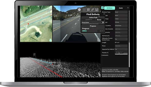
Asula Extract is an enterprise cloud-based platform for large-scale LiDAR feature extraction, auditing, and delivery across infrastructure industries. Manage projects, collaborate with teams, and process datasets entirely in the cloud.
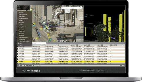
Asula Visualize is a secure cloud-based GIS platform that allows clients to easily explore LiDAR data, imagery, and GIS layers directly in their browser. Share interactive mapping projects securely without installing any additional software.
The Complete Enterprise Mapping Software Ecosystem
Fast, Scalable Uploads
Quickly upload large LiDAR and imagery datasets using our cloud infrastructure. Start LiDAR data extraction services faster while eliminating hardware bottlenecks.
Client-Ready Mapping
Deliver browser-based access to LiDAR data, imagery, and GIS layers through Asula Visualize (AVI), enabling clients to review, validate, and interact with projects from anywhere.
Team-Scale Project Management
Coordinate multiple extraction teams through one centralized platform with real-time collaboration, project tracking, and quality control for enterprise mapping projects.
Project-Specific Extraction Tools
Create custom data dictionaries for consistent LiDAR feature extraction, standardized asset classification, and accurate project delivery across every extraction workflow.
Fluid 3D Extraction Environment
Powered by cloud rendering and the Unity engine, Asula Extract (AEX) provides an intuitive workspace for point cloud extraction and advanced 3D geospatial analysis without requiring high-end workstations.
REMOTE RENDERING
Cloud Rendering for Faster Geospatial Intelligence
Asula Geospatial processes and renders LiDAR datasets entirely in the cloud, giving organizations the performance needed for large-scale geospatial intelligence, enterprise mapping software, and mobile mapping projects. Reduce hardware costs while improving collaboration, scalability, and project delivery.
Ready to Modernize Your LiDAR Mapping Workflow?
Experience a complete cloud platform for LiDAR data organization, storage, extraction, conflation, and quality control. Book a personalized demo and discover how Asula Geospatial simplifies every stage of your 3D geospatial workflow.